Zion National Park maps are essential tools for planning and navigating the park’s trails, scenic drives, and wilderness areas. The Zion Map PDF provides detailed information on trails, shuttle routes, and visitor facilities, helping visitors make the most of their trip while adhering to park regulations.
Overview of Zion National Park
Zion National Park, located in southwestern Utah, is renowned for its steep cliffs, narrow canyons, and diverse wildlife. The park features the Virgin River, which carves through the landscape, creating breathtaking scenery. Key areas include Zion Canyon, Kolob Canyons, and the Temple of Sinawava. Maps are crucial for navigating the park’s trails, scenic drives, and wilderness areas. The Zion Map PDF highlights main roads, tunnels, shuttle stops, and attractions, ensuring visitors can explore safely and efficiently. With its unique geological formations and varied ecosystems, Zion offers an unforgettable experience for hikers, photographers, and nature enthusiasts alike.
The Importance of Maps for Visitors
Maps are indispensable for visitors to Zion National Park, providing critical information for navigating trails, scenic drives, and facilities. The Zion Map PDF guides visitors through the park’s complex layout, highlighting key attractions and trails like Emerald Pools and the Grotto Trail. It also details shuttle routes and parking areas, essential during peak seasons when private vehicles are restricted. Maps ensure visitors stay informed about regulations and safety, helping them avoid potential hazards and respect protected wilderness areas. With a map, visitors can plan their itinerary effectively, maximizing their exploration of Zion’s natural wonders while staying safe and informed.

Types of Zion Maps Available
Zion offers various maps, including the Zion Map PDF, Wilderness Map, and Scenic Drive Map, each tailored for different activities like hiking, exploring, or driving.
Zion National Park Map PDF
The Zion National Park Map PDF is a downloadable guide that provides detailed information about the park’s trails, scenic drives, and facilities. It includes key attractions like Emerald Pools Trail, Kayenta Trail, and the Grotto Trail, as well as shuttle routes and visitor centers. The map highlights wilderness areas, regulations, and safety tips, ensuring visitors are well-prepared for their adventure. Available on the park’s official website, the PDF is a must-have for planning and navigating Zion’s diverse landscapes. It’s also printable, making it a reliable resource for offline use during your visit.
Zion Wilderness Map
The Zion Wilderness Map is a comprehensive guide for exploring the park’s backcountry and protected areas. Available as a PDF, it details trails, regulations, and Leave No Trace principles to preserve the environment. The map highlights restricted zones, permit requirements, and essential safety guidelines for hikers and campers. It also identifies key trailheads and wilderness boundaries, ensuring visitors navigate responsibly. Designed for adventurers seeking to immerse themselves in Zion’s natural beauty, the map is a crucial resource for planning backcountry trips and understanding the park’s conservation efforts. It’s downloadable from the park’s official website for easy access before your journey.
Zion Canyon Scenic Drive Map
The Zion Canyon Scenic Drive Map guides visitors through one of the park’s most stunning routes. Available as a PDF, it outlines the shuttle-only sections during peak seasons and restricted areas for private vehicles beyond Canyon Junction. The map highlights scenic stops, attractions, and points of interest along the drive, such as the Temple of Sinawava and the Great Arch of Zion. It also notes tunnel restrictions for large vehicles and provides insights into parking options in Springdale to avoid congestion. This map is a must-have for those aiming to explore Zion’s breathtaking canyon landscapes efficiently and responsibly.

Key Features of Zion Maps
Zion maps highlight trails, facilities, regulations, and scenic drives, aiding navigation and planning for visitors exploring Zion’s unique landscapes responsibly.
Trails and Hiking Routes
Zion National Park maps detail an extensive network of trails, ranging from easy walks like the Emerald Pools Trail to more challenging routes such as the Kayenta and Grotto trails. The Zion Map PDF provides precise trailhead locations, distances, and difficulty levels, ensuring hikers can plan their adventures effectively. It also highlights scenic overlooks and connects trails to key landmarks like the Temple of Sinawava. The map is indispensable for navigating Zion’s rugged terrain, offering insights into trail conditions and regulations to help visitors explore safely while respecting the park’s natural wonders and unique rock formations.
Scenic Drives and Shuttle Routes
Zion National Park maps highlight the scenic drives and shuttle routes, such as the Zion Canyon Scenic Drive, which is accessible only by shuttle during peak seasons. The Zion Map PDF provides detailed routes, stops, and access points, helping visitors navigate the park’s stunning landscapes. Key stops like the Temple of Sinawava and scenic viewpoints are marked, along with tunnel restrictions and parking areas. The map also outlines seasonal access limitations, ensuring visitors are aware of when private vehicles are allowed beyond Canyon Junction. This feature is essential for planning a smooth and enjoyable drive-through experience in Zion.
Visitor Centers and Facilities
Zion National Park maps, including the Zion Map PDF, provide essential details about visitor centers and facilities. The main visitor center near the park’s entrance offers information, permits, and guides. Additionally, facilities like restrooms, picnic areas, and parking lots are marked on the map, helping visitors plan their day. Key locations such as the Temple of Sinawava and other amenities are highlighted, ensuring easy access to services. The map also indicates areas with limited facilities, helping visitors prepare for their adventure. This feature is crucial for a convenient and enjoyable experience in Zion National Park.
Wilderness Areas and Regulations
The Zion Map PDF includes detailed information about wilderness areas and regulations to ensure responsible exploration. These maps highlight restricted zones, necessary permits, and guidelines for backcountry access. They also emphasize Leave No Trace principles, helping visitors minimize their impact on the environment. The maps outline specific rules for camping, fires, and waste disposal, ensuring the preservation of Zion’s natural beauty. By referencing these maps, visitors can navigate the wilderness responsibly while adhering to park regulations. This resource is crucial for maintaining the integrity of Zion’s ecosystems and ensuring a safe, enjoyable experience for all explorers.
Popular Trails in Zion
Zion’s map PDF highlights popular trails like Emerald Pools, Kayenta, and Grotto, guiding visitors to scenic destinations and iconic attractions within the park.
Emerald Pools Trail
The Emerald Pools Trail is one of Zion’s most beloved hikes, offering stunning views of waterfalls and lush vegetation. The trail spans 3.2 miles round trip, with moderate difficulty, making it accessible to hikers of all skill levels. The path leads to three pools, each surrounded by vibrant greenery, creating a serene oasis within the park. The Zion Map PDF highlights this trail, providing clear directions and trailhead locations. Visitors can access the trail via the Zion Canyon Shuttle, ensuring an efficient and enjoyable experience. This hike is a must-do for nature enthusiasts and families alike, showcasing Zion’s natural beauty;
Kayenta Trail
The Kayenta Trail is a 2-mile loop with easy to moderate difficulty, offering stunning views of Zion’s red rock formations. It connects to the Emerald Pools Trail and the West Rim Trail, making it a versatile option for hikers. The Zion Map PDF provides detailed trailhead locations and route connections, ensuring visitors can navigate effortlessly. This trail is ideal for those seeking a mix of scenic vistas and accessible terrain.
The Kayenta Trail is popular for its well-marked paths and breathtaking overlooks. It’s a great choice for families and hikers looking to explore Zion’s diverse landscapes. Use the Zion Map PDF to plan your adventure and make the most of your visit.
Grotto Trail
The Grotto Trail is a short, family-friendly hike in Zion National Park, offering a peaceful walk along the Virgin River. The trail is 1 mile round trip and leads to a natural grotto with lush vegetation and a small spring. It’s an excellent choice for those seeking a relaxing stroll. The Zion Map PDF highlights the trail’s location near the Zion Lodge and provides information on parking and shuttle access. This trail is perfect for visitors looking to escape the crowds and enjoy Zion’s natural beauty without intense physical exertion.

Visitor Information
Zion’s visitor information includes maps, guides, and park details. Visitor centers offer insights into trails, facilities, and regulations, ensuring a well-planned and enjoyable visit.
Zion National Park Visitor Centers
Zion National Park Visitor Centers are hubs for information and planning. Located at the park’s entrance and within the canyon, they provide maps, brochures, and expert advice. Rangers offer insights into trails, scenic drives, and safety tips. The centers also showcase exhibits on Zion’s natural and cultural history. Visitors can download the Zion Map PDF here, which details trails, shuttle routes, and facilities. These centers are essential for orienting oneself and maximizing the park experience while staying informed about regulations and conditions.
Planning Your Visit
Planning your visit to Zion National Park begins with downloading the Zion Map PDF, which offers a comprehensive guide to trails, scenic drives, and facilities. This map helps visitors identify key attractions, such as iconic trails like Emerald Pools and the Kayenta Trail, as well as essential services like visitor centers and shuttle stops. By reviewing the map beforehand, visitors can create an itinerary that suits their interests and physical abilities, ensuring a well-organized and enjoyable trip. Understanding the park’s layout and regulations is crucial for a seamless and safe experience.
Park Regulations and Safety Tips
The Zion Map PDF highlights important park regulations and safety tips to ensure a safe and enjoyable visit. Visitors must stay on designated trails, and off-trail hiking in wilderness areas requires a permit. The Zion Canyon Scenic Drive is accessible only by shuttle during peak seasons, and private vehicles are restricted beyond Canyon Junction. Parking in Springdale is recommended to avoid congestion. Always carry water, sunscreen, and a map, as weather conditions can change rapidly. Respect wildlife and follow Leave No Trace principles to preserve Zion’s natural beauty. Familiarizing yourself with these guidelines ensures a secure and responsible exploration of the park.

Wilderness and Backcountry Information
The Zion Map PDF provides essential details on backcountry permits, restricted areas, and guidelines for exploring Zion’s wilderness, ensuring safe and responsible adventures in the park.
Zion Wilderness Map Details
The Zion Wilderness Map provides comprehensive details on the park’s backcountry, including trails, restricted areas, and essential regulations. Available as a PDF, it highlights key wilderness zones like Kolob Canyons and Zion Canyon. The map also outlines Leave No Trace principles, ensuring visitors minimize their impact on the environment. It’s a crucial resource for hikers and adventurers planning to explore Zion’s rugged terrain responsibly. By referencing this map, visitors can navigate safely and stay informed about permits and closures, making it indispensable for a well-prepared wilderness experience in Zion National Park.
Leave No Trace Principles
Leave No Trace principles are essential for preserving Zion’s natural beauty and wildlife. The Zion Map PDF emphasizes these guidelines to promote responsible exploration. Key principles include staying on designated trails, disposing of waste properly, and avoiding disturbance of wildlife. Visitors are encouraged to plan ahead, minimize campfire impacts, and refrain from removing plants or rocks. By following these principles, visitors help protect Zion’s fragile ecosystem for future generations. The map integrates these guidelines, ensuring that adventurers can enjoy the park while maintaining its pristine condition. Adhering to Leave No Trace ensures a harmonious relationship between visitors and Zion’s unique environment.
Backcountry Permits and Restrictions
Backcountry permits are required for overnight trips in Zion’s wilderness areas, including popular routes like the West Rim and The Narrows. These permits ensure sustainable visitation and protect sensitive habitats. Group sizes are limited to minimize environmental impact, and some areas, such as certain slot canyons, may require reservations. The Zion Map PDF outlines restricted zones and provides guidance on obtaining permits, which can be secured at the Zion Wilderness Desk or online. Adhering to these regulations helps preserve the park’s natural beauty and ensures a safe, enjoyable experience for all visitors. Planning ahead is crucial for a smooth backcountry adventure.

Zion Canyon Scenic Drive
Zion Canyon Scenic Drive offers stunning views, accessible via shuttle buses during peak seasons. The Zion Map PDF highlights scenic stops and attractions along the route.
Shuttle Service and Access
Zion Canyon Scenic Drive is accessible primarily via shuttle buses during peak seasons, as private vehicles are restricted beyond Canyon Junction. The Zion Map PDF outlines shuttle routes, stops, and accessible trailheads, helping visitors navigate the park efficiently. Parking is available in Springdale, with shuttles providing convenient access to key attractions. The map also highlights restricted areas, such as tunnels where bikes and pedestrians are prohibited. This service ensures a smooth and enjoyable experience, allowing visitors to focus on the park’s stunning landscapes while adhering to safety and environmental guidelines.
Scenic Stops and Attractions
Zion National Park offers breathtaking scenic stops and attractions, as detailed in the Zion Map PDF. Key highlights include the Temple of Sinawava, Kolob Canyons, and Mount Spry, offering stunning views and diverse landscapes. The map also identifies picnic areas, bridges, and viewpoints along the scenic drives, ensuring visitors don’t miss iconic spots. With the map’s guidance, explorers can easily locate the Beehives and Sentinel formations, adding to the park’s natural charm. These attractions showcase Zion’s unique geological beauty, making the map an invaluable resource for planning an unforgettable adventure.
Seasonal Access and Restrictions
Zion National Park’s seasonal access varies, with key details outlined in the Zion Map PDF. From spring to fall, the Zion Canyon Scenic Drive is open only to shuttle buses, while private vehicles are restricted beyond Canyon Junction. In winter, the drive opens to private vehicles, offering a quieter experience. The map highlights tunnel restrictions for large vehicles and RVs, advising travelers to check height clearances. Additionally, seasonal closures may affect certain trails or facilities, such as showers, which are not available within the park. Planning around these seasonal changes ensures a smooth and enjoyable visit to Zion’s stunning landscapes.

Points of Interest
Zion’s Temple of Sinawava, Kolob Canyons, and Mount Spry and The Beehives are key attractions, offering breathtaking views and unique geological features for visitors to explore.
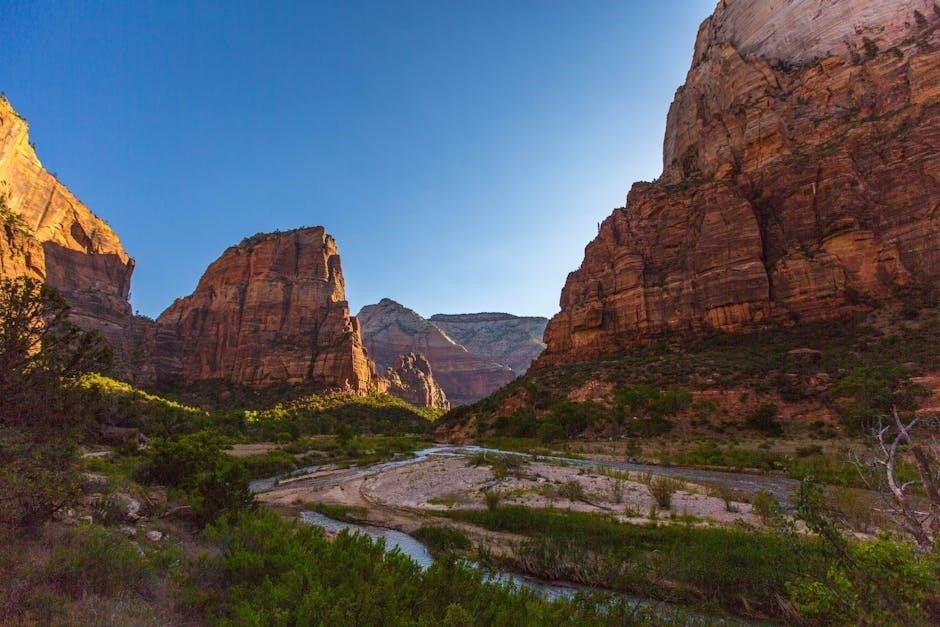
Temple of Sinawava
The Temple of Sinawava is a striking rock formation at the mouth of Zion Canyon, near the Virgin River. It is one of Zion’s most iconic landmarks and a popular stop along the Zion Canyon Scenic Drive. The area features lush vegetation and natural springs, creating a serene atmosphere. Visitors can explore the Riverside Walk, a paved trail that begins at the Temple of Sinawava and follows the Virgin River. This site is also a great spot for photography, especially during the golden hours of sunrise or sunset. Shuttle stops provide easy access to this breathtaking location.
Kolob Canyons
Kolob Canyons is a lesser-known but equally breathtaking section of Zion National Park, located northwest of the main canyon. Known for its stunning red rock formations and deep, narrow gorges, Kolob Canyons offers a peaceful escape from the crowds. The area features scenic drives, hiking trails, and picnic areas, making it a perfect spot for those seeking solitude and natural beauty. The Kolob Canyons Trail provides access to the backcountry, while the scenic viewpoints along the Kolob Canyons Road offer spectacular photo opportunities. This unique landscape is a must-visit for anyone exploring Zion National Park’s diverse wonders.
Mount Spry and The Beehives
Mount Spry and The Beehives are prominent landmarks within Zion National Park, offering iconic views and unique geological formations. Located near the park’s west rim, these formations attract hikers and photographers alike. The Zion map highlights trails leading to these areas, such as the West Rim Trail, which offers breathtaking vistas. Elevations for Mount Spry and The Beehives are 5,823 feet and 6,904 feet, respectively. These natural wonders are a testament to Zion’s diverse landscape, blending rugged beauty with accessible trails for exploration. Visitors are encouraged to respect these areas and follow park regulations to preserve their natural integrity.

Practical Information
Download the Zion map PDF for essential details on trails, scenic drives, and facilities. Use GPS and digital maps for real-time navigation, ensuring a smooth park experience.
Downloading the Zion Map PDF
Downloading the Zion map PDF is a convenient way to access detailed park information. The PDF includes trails, scenic drives, and regulations, ensuring visitors are well-prepared. Available on the official Zion National Park website, the map is free and easy to download. It features key locations like visitor centers, trailheads, and scenic stops, making it an essential resource for planning. The PDF is compatible with both desktop and mobile devices, allowing users to navigate the park offline. By downloading the map, visitors can explore Zion’s beauty confidently, knowing they have all the necessary information at their fingertips.
Using GPS and Digital Maps
GPS and digital maps are invaluable tools for navigating Zion National Park. Popular apps like Google Maps and park-specific platforms offer real-time directions for trails and scenic drives. However, internet access is limited within the park, so downloading maps or the Zion map PDF beforehand is highly recommended. GPS devices can help pinpoint trailheads, scenic stops, and facilities, ensuring visitors stay on track. Digital maps also provide overlays with up-to-date information on trail closures or park events. Combining GPS with a downloaded map enhances navigation reliability, especially in areas with poor connectivity, making exploration safer and more efficient for all visitors.

Parking and Shuttle Services
Parking in Zion National Park can be challenging, especially during peak seasons. The main parking lots fill quickly, so arriving early is recommended. The Zion Canyon Scenic Drive is closed to private vehicles from spring to fall, with shuttle services providing access to key attractions. Visitors can park at the Zion Canyon Visitor Center or in Springdale and ride the free shuttle into the park. The shuttle stops at trailheads, scenic viewpoints, and facilities, making it a convenient option for exploring. Using the park’s shuttle system helps reduce traffic and parking congestion, enhancing the overall visitor experience while protecting the environment.
Zion National Park maps are indispensable for navigating trails, scenic drives, and regulations. Stay informed, plan ahead, and enjoy a memorable adventure in Zion’s stunning landscapes responsibly.
Final Tips for Visiting Zion
Download the Zion Map PDF for detailed trail and shuttle information. Plan ahead by checking shuttle schedules and parking options. Bring water, sunscreen, and sturdy shoes. Respect park regulations and wildlife. Stay informed about weather conditions and trail closures. Carry a map and GPS for navigation. Enjoy scenic drives and hikes responsibly, adhering to Leave No Trace principles. Plan your visit during less busy seasons for a more serene experience. Always check in at visitor centers for up-to-date information. Be prepared for variable weather and challenging terrain. Make the most of your Zion adventure while preserving its natural beauty.
Staying Informed and Prepared
Before your trip, download the Zion Map PDF to familiarize yourself with trails, shuttle routes, and facilities. Check the park’s website for up-to-date trail closures and weather alerts. Carry a physical map, compass, and GPS device as backup. Pack essentials like water, snacks, and sun protection. Plan your itinerary according to your fitness level and time constraints. Stay aware of park rules, such as no drones in wilderness areas. Inform someone about your plans and expected return time. Be mindful of seasonal restrictions, like limited shuttle access during winter. Stay safe by knowing your limits and the environment.